
Completion Date
6-1-2008
Advisor
Matthew Kelly
Abstract/Description
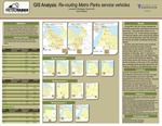
Abstract:The purpose of this research was to create the most efficient driving routes for Metro Parks service vehicles using ESRI’s ARC GIS software. Currently the Metro Parks service vehicles do not have predetermined routes, or any sort of tracking devices like GPS. The results of new efficient driving routes include reduced drive time, reduced fuel costs, and more accountability for drivers.
Recommended Citation
Pfingston, Jason, "GIS Analysis: Re-routing Metro Parks service vehicles" (2008). GIS Certificate Projects. 12.
https://digitalcommons.tacoma.uw.edu/gis_projects/12
COinS