
Completion Date
6-1-2008
Advisor
Matthew Kelly
Abstract/Description
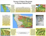
Abstract:This map displays the geographic extent of Olympic National Park. In addition, 139 historic structures and the existing primary trails and roadways that run through park boundaries are present. Extent rectangles on this map correspond to inset maps of the same color. These maps highlight areas of specific ilocation and provide a description of a historic building of particular interest. The map to the right of the base map shows the routes of the Press and O'Niel Expeditions of the late 19th century. The lines in red represent modern trails and roads. This map is designed to provide a better context of the historic resources of Olympic National Park.
Recommended Citation
Malfet, Frank, "Survey of Historic Structures In Olympic National Park" (2008). GIS Certificate Projects. 8.
https://digitalcommons.tacoma.uw.edu/gis_projects/8
COinS